In Albury-Wodonga, much of the subgrade sits on alluvial silts and clays deposited by the Murray River, which means water management is the single biggest factor in pavement longevity. Without proper geotechnical road drainage, even a well-compacted base course can saturate and lose bearing capacity within two wet seasons. Before specifying drainage, we typically run a permeability test in the field to measure in-situ hydraulic conductivity, and we often pair this with a plate load test to confirm the subgrade reaction modulus under saturated conditions. These two field checks give us the baseline data needed to size trench drains, blanket drains, and edge drains correctly for the local soil profile.
Saturated subgrade can lose 50% of its California Bearing Ratio within days of a rainfall event in Albury-Wodonga's alluvial clays.
Methodology and scope
Local considerations
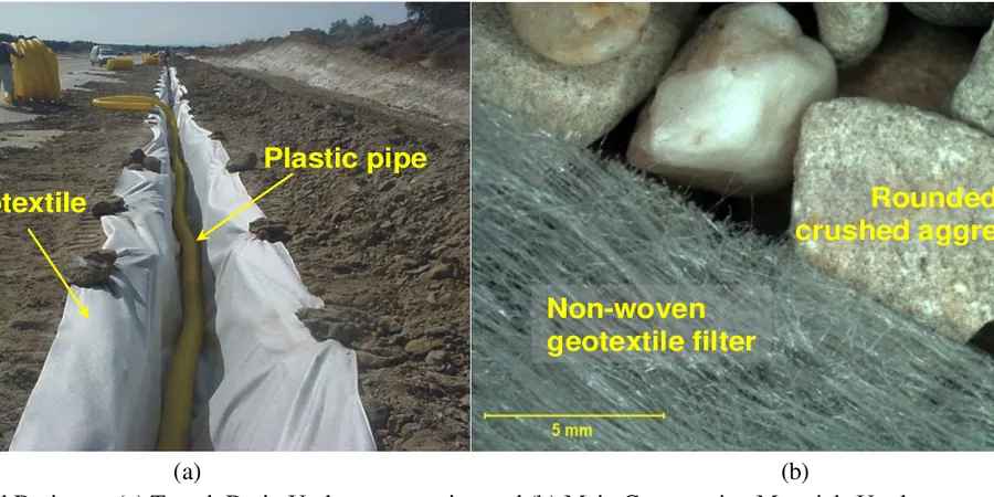
A mistake we see repeatedly in Albury-Wodonga road projects is installing perforated drainage pipes without a proper filter envelope. When the surrounding trench backfill has a fines content above 12%, the pipe slots clog within 18 months and the entire geotechnical road drainage system becomes ineffective. The result is water ponding in the pavement base, differential frost heave in colder months, and premature fatigue cracking. Another common error is terminating outlet pipes at the toe of the fill without energy dissipation, which causes localised scour and undermines the shoulder. Both failures are preventable with a filter design based on the actual particle size distribution of the in-situ soil.
Applicable standards
AS 1726:2017 Geotechnical site investigations, AS 4678:2002 Earth-retaining structures, Austroads AGRD04 Guide to Road Design Part 4: Drainage, AS/NZS 1170.2:2011 Structural design actions — Wind actions
Associated technical services
Subsurface Drainage Design and Filter Specification
We prepare detailed drainage layouts including slotted pipe size, geotextile wrap selection, filter aggregate grading, and outlet spacing. All designs reference the in-situ permeability data and the subgrade CBR obtained from laboratory testing. We also provide construction specifications for trench excavation, pipe bedding, and backfill compaction.
Drainage Performance Monitoring and Troubleshooting
For existing roads showing signs of moisture damage — pumping joints, rutting, or shoulder settlement — we install observation wells and flow meters to diagnose the failure mechanism. We then recommend retrofit solutions such as horizontal drains, interception trenches, or daylighting the existing system. This service is particularly valuable for older sections of the Hume Highway corridor.
Typical parameters
Frequently asked questions
Why is geotechnical road drainage more critical in Albury-Wodonga than in other regions?
The Murray River floodplain creates a shallow water table and fine-grained alluvial soils that retain moisture. Without engineered drainage, the subgrade stays near saturation for weeks after rain, reducing its California Bearing Ratio by up to 60% and causing pavement deflection and cracking. The freeze-thaw cycles in winter further accelerate damage when trapped water expands.
What is the typical cost range for a geotechnical road drainage investigation and design in Albury-Wodonga?
For a standard road project, the investigation and design phase typically falls between AU$1,180 and AU$4,220, depending on the length of the road, the number of test pits or boreholes required, and the complexity of the drainage layout. This includes field permeability testing, particle size analysis, and a detailed drainage design report with construction specifications.
How long does a geotechnical road drainage system last before it needs maintenance?
A properly designed and constructed drainage system — with appropriate filter grading, geotextile separation, and outlet protection — typically functions effectively for 20 to 30 years with minimal maintenance. The main failure mode is clogging of the filter layer or geotextile by fines migration, which can be delayed by specifying a filter with D₁₅/D₈₅ ratio below 5 as per AS 4678.